


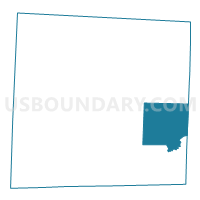
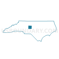
Voting District 17, Randolph County, North Carolina
About
Outline

Summary
| Unique Area Identifier | 641197 |
| Name | Voting District 17 |
| County | Randolph County |
| State | North Carolina |
| Area (square miles) | 48.86 |
| Land Area (square miles) | 48.77 |
| Water Area (square miles) | 0.09 |
| % of Land Area | 99.82 |
| % of Water Area | 0.18 |
| Latitude of the Internal Point | 35.65954180 |
| Longtitude of the Internal Point | -79.61936770 |
Maps

Graphs
Select a template below for downloading or customizing gragh for Voting District 17, Randolph County, North Carolina


Neighbors
Neighoring Voting District (by Name) Neighboring Voting District on the Map
- Voting District 14, Randolph County, NC
- Voting District 20, Randolph County, NC
- Voting District 21, Randolph County, NC
- Voting District 27, Randolph County, NC
- Voting District 31, Randolph County, NC
- Voting District 34, Randolph County, NC
- Voting District 6, Chatham County, NC
- Voting District 85, Chatham County, NC
Top 10 Neighboring County Subdivision (by Population) Neighboring County Subdivision on the Map
- Matthews township, Chatham County, NC (13,442)
- Franklinville township, Randolph County, NC (10,080)
- Columbia township, Randolph County, NC (7,016)
- Grant township, Randolph County, NC (6,336)
- Richland township, Randolph County, NC (3,811)
- Bear Creek township, Chatham County, NC (3,602)
- Coleridge township, Randolph County, NC (2,290)
- Brower township, Randolph County, NC (1,409)
- Pleasant Grove township, Randolph County, NC (571)
Top 10 Neighboring Unified School District (by Population) Neighboring Unified School District on the Map
Top 10 Neighboring State Legislative District Lower Chamber (by Population) Neighboring State Legislative District Lower Chamber on the Map
- State House District 54, NC (83,728)
- State House District 70, NC (72,392)
- State House District 78, NC (69,360)
Top 10 Neighboring State Legislative District Upper Chamber (by Population) Neighboring State Legislative District Upper Chamber on the Map
Top 10 Neighboring 111th Congressional District (by Population) Neighboring 111th Congressional District on the Map
Top 10 Neighboring Census Tract (by Population) Neighboring Census Tract on the Map
- Census Tract 310, Randolph County, NC (7,151)
- Census Tract 308.01, Randolph County, NC (7,148)
- Census Tract 308.02, Randolph County, NC (6,290)
- Census Tract 205, Chatham County, NC (3,751)
- Census Tract 309, Randolph County, NC (3,686)
- Census Tract 203, Chatham County, NC (2,929)